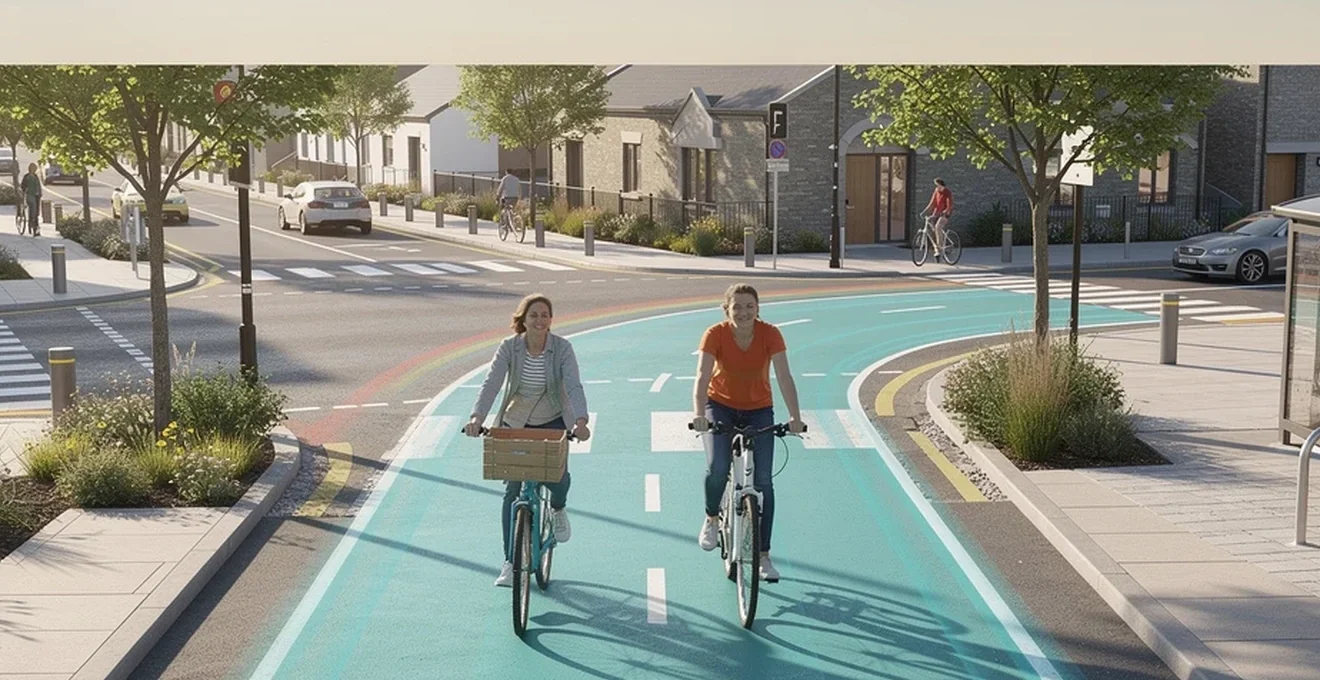
Creating streets and public spaces that genuinely work for people cycling requires more than painting a white line on the carriageway. It demands careful attention to network design, junction safety, parking provision and materials, all underpinned by an understanding of how different people move through space. This guide sets out the practical principles behind bike-friendly public realm design, drawing on established infrastructure typologies, junction safety research and current UK and international guidance. Whether you are a planner, designer or simply curious about why some streets feel safe to cycle on and others do not, the sections below explain the building blocks of good cycling infrastructure — from segregated tracks and protected junctions to parking systems and sustainable surfacing — and how they combine to create places that are safe, legible and genuinely inclusive for everyone.
Cycling infrastructure typologies: from protected lanes to shared streets
The starting point for any bike-friendly street is recognising that people generally do not like cycling amongst motor traffic, nor mixing with pedestrians. On streets carrying significant traffic volumes, the primary requirement for making cycling an easy and attractive choice is dedicated space for cycling, with at least 2.1 metres provided on each side of the road and some degree of protection from vehicles. Getting this right on primary and secondary streets is the single biggest factor in whether ordinary people choose to cycle.
Segregated cycle tracks and the dutch CROW manual standards
The best-practice approach, widely used in the Netherlands, is the fully segregated cycle track. These tracks should be 2.5 metres wide (2.1 metres as an absolute minimum) on both sides of the road, machine-laid, and separated from the main carriageway by at least one metre of green space, or by car and cycle parking. Kerbing should be forgiving — shallow and/or angled — both to reduce the risk of accidents and to make the maximum width of the track usable.
The CROW Design Manual for Bicycle Traffic remains a reference standard for these dimensions and for verge widths alongside cycle tracks, recommending at least 0.5 metres of firm verge next to a track to reduce risk to anyone who drifts off the path. In the UK, Local Transport Note 1/20 (LTN 1/20) draws on similar principles, setting minimum widths of 2 metres for one-way tracks and 3 metres for two-way tracks, excluding kerbs, gutters and drainage covers.
Painted bike lanes versus Kerb-Protected cycleways
Painted cycle lanes that are part of the carriageway, without physical protection, are frequently driven or parked in and should be considered as shared space with motor traffic rather than genuinely protected infrastructure. Protected cycle lanes, by contrast, use kerbing, planters, parked cars or other physical barriers to separate cyclists from drivers.
An effective middle option is the hybrid cycle lane, used successfully in Denmark and Sweden and now featured in UK design guidance. These are on-road lanes with light physical demarcation — cobbles or a similar informal barrier — that give less confident cyclists a feeling of protection without the full cost of a segregated track. Hybrid lanes should be around 2.5 metres wide (2.1 metres minimum), finished in red surfacing, and raised slightly above the level of the main carriageway, with footways constructed separately and raised slightly higher again. Where car parking is required alongside these lanes, it should sit between the cycle track and the traffic lanes, with a width of 2.5 metres avoiding the risk of car doors opening into the path of cyclists (narrower widths need a 50cm buffer zone).
Layer separation — cycle tracks higher than the road but lower than the footway — combined with clear colour contrast helps every user understand where they should be. Protected lanes tend to work best where speed limits are capped at 30mph or below.
Woonerf and Shared-Space models: lessons from hans monderman’s legacy
Not every street needs, or benefits from, strict segregation. On very low-traffic streets, shared-space approaches — informed by the Dutch woonerf concept and the work of traffic engineer Hans Monderman — reduce the dominance of motor vehicles by removing conventional kerbs, signage and road markings, encouraging drivers to behave more cautiously and defer to pedestrians and cyclists. These models depend on very low traffic volumes and speeds to work safely.
It is worth noting that shared spaces are not universally accessible: routes shared between people cycling and people walking or wheeling can pose real risks to some disabled pedestrians, particularly those with visual impairments, who rely on predictable kerblines and clear demarcation. Where shared space is used, a detectable kerb of at least 60mm separating cycling and walking areas, with strong visual contrast between surfaces, is considered good practice for accessibility. Designers should treat shared space as a deliberate trade-off rather than a default aesthetic choice.
Contraflow cycling schemes in Low-Traffic neighbourhoods (LTNs)
Low-Traffic Neighbourhoods use modal filters — such as bollards, planters or camera-enforced restrictions — to remove through motor traffic from residential streets while keeping them open to people walking, wheeling and cycling. Contraflow cycling permits people to cycle in both directions along streets that are one-way for motor vehicles, significantly improving route directness without requiring wholesale reconstruction.
Where filters are used to prevent car access, vehicle restriction bollards should be spaced with a minimum 1.5-metre gap and allow straight-line access for the full range of cycle types, based on the Cycle Design Vehicle, which has a 4-metre external turning radius. This detail matters because narrow or awkwardly placed barriers, even when well-intentioned, can exclude tricycles, cargo bikes and handcycles used by many disabled people, and may amount to unlawful discrimination under the Equality Act 2010.
Junction design and intersection safety for cyclists
Junctions are the most common location for collisions involving cyclists, and reported casualty data consistently shows this pattern. A well-designed junction reduces the number of decisions each road user has to make simultaneously. The guiding principles are maintaining separation through the junction, reducing the number of interactions with other traffic, ensuring good visibility through perpendicular crossing points, avoiding repeated stop-start manoeuvres, and reducing vehicle speeds through the junction itself.
Dutch-style protected intersections and corner refuge islands
The Dutch protected intersection design places a small corner refuge island between the cycle track and the traffic lane at each arm of a junction. This achieves two things: it sets cyclists back from the corner so that turning drivers have a clear sightline to them before completing a turn, and it allows cyclists to cross in a way that never requires looking in more than one direction at once to move safely.
Cycle lanes should be marked clearly across the junction itself to indicate the space a cyclist requires and to reduce the likelihood of collisions with left-turning vehicles. Where a cycle track must cross more than one lane of traffic, or traffic moving in multiple directions, a safe refuge of at least 2.4 metres should be provided between lanes; where this is not achievable, signalisation or grade separation becomes necessary.
Advanced stop lines (ASLs) and bike boxes at signalised crossings
Advanced stop lines allow cyclists to position themselves ahead of stationary traffic at signals, giving better visibility and a head start when the lights change. However, they are not a universally inclusive solution: reaching an ASL typically requires filtering past queuing traffic, which can be intimidating or physically difficult for slower-moving cyclists, including many disabled cyclists and those on longer or wider non-standard cycles. Designers should treat ASLs as a partial measure rather than a substitute for full separation at busy junctions.
Roundabout design: turbo roundabouts and CYCLOPS junctions in manchester
Conventional roundabouts are notoriously difficult to make safe for cycling because they require merging with fast-moving, multi-directional traffic. One well-established alternative is the one-way, bicycle-only roundabout, where cycle traffic moves around the outside of a standard four-way vehicle junction — effectively a dedicated cycling roundabout wrapped around the main junction, a principle already used in Dutch practice.
In the UK, CYCLOPS junctions (Cycle Optimised Protected Signals) apply similar thinking to signalised crossroads: cyclists and pedestrians travel around the outside of the junction on a fully separated track with their own signal stages, entirely removed from conflict with turning vehicles. This design has been implemented in Manchester as part of the city’s strategic cycling network and represents one of the clearer examples of best-practice UK junction design translating Dutch principles into a signal-controlled context.
Signal timing strategies: simultaneous green and leading cyclist intervals
Waiting times matter a great deal to how attractive cycling feels. Waits of more than around 30 seconds make cycling slow and unattractive, discouraging use of otherwise well-designed infrastructure. Signal strategies that give cycle traffic the same direct routes over a junction as cars, with more frequent but shorter green phases, help maintain momentum. Two specific approaches are worth considering: advanced green signals that release cyclists slightly ahead of general traffic, and simultaneous green phases that allow cycling movements in multiple directions at once, similar to an all-way pedestrian phase. Both reduce conflict points and cut the number of stages a cyclist must navigate to cross a junction safely.
Urban planning frameworks supporting active travel
Individual junctions and lanes only deliver their full benefit when embedded in a coherent network and policy framework. Cities that have become genuinely bike-friendly have typically combined infrastructure investment with supportive planning policy, traffic reduction and a long-term commitment to active travel as a core mode of transport rather than an afterthought.
The copenhagenize index and benchmarking Bike-Friendly cities
International comparisons of cycling-friendly cities have historically used benchmarking indices to compare infrastructure quality, modal share, policy commitment and cycling culture across major urban areas. These comparative exercises have been influential in encouraging cities to learn from one another, whether through direct study visits — such as architects and planners cycling between cities to compare infrastructure firsthand — or through adopting specific design details that have proven successful elsewhere, from Copenhagen’s kerb-separated one-way cycle lanes to Freiburg’s continuous, consistently signed protected network.
Vision zero policy integration with cycling network design
Vision Zero — the principle that no loss of life on the road network is acceptable, and that system design rather than individual blame should drive safety improvements — depends heavily on how cycling networks are designed. Lower speed limits, physical protection at junctions, and removal of « cycling amongst traffic » as a default all reduce the severity and frequency of collisions. Enforcement measures such as minimum overtaking distances for drivers passing cyclists (a berth of one metre or more, already law in a number of jurisdictions) and requirements for close-proximity sensors and improved mirrors on lorries and buses support the same aim: reducing the consequences of driver error rather than relying solely on cyclist vigilance.
Modal filtering and traffic calming under the LTN 1/20 guidance
LTN 1/20, the UK Department for Transport’s cycle infrastructure design guidance, sets out core thresholds for when cyclists can safely share carriageway space with drivers: speed limits no higher than 20mph, good sight lines, effective enforcement, and traffic volumes below roughly 2,500 vehicles per day. Above these thresholds, physical separation becomes necessary. Modal filters, 20mph zones, and physical speed-reducing measures together make many urban and rural roads suitable for largely inclusive on-carriageway cycling, though some cyclists — including many disabled cyclists — will always need fully traffic-free alternatives regardless of how calm a shared street becomes.
Bicycle parking systems and End-of-Trip facilities
Good routes are only half the journey. Without secure, convenient parking at the destination, much of the benefit of high-quality cycling infrastructure is lost. Parking provision needs to anticipate demand rather than react to it: regular monitoring and capacity increases are essential wherever accessible or standard bays are becoming full.
On-street bike hangars versus Multi-Storey cycle parks
On-street bike hangars — lockable, weatherproof units installed in former car parking bays — offer secure residential storage for people without space at home, and are particularly valuable in dense terraced housing where back-garden or hallway storage is impractical. Multi-storey or large-format cycle parks, typically found at transport hubs and town centres, suit higher-volume destinations but need careful attention to step-free access, turning circles and gradients; very few cycle types can reverse, so roll-in, roll-out layouts matter more than raw capacity.
Sheffield stands, wave racks and vertical storage solutions
The Sheffield stand — a simple inverted-U shape — remains one of the most secure and widely recommended standard parking fixtures, allowing a cycle frame and both wheels to be locked without risk of wheel-bending associated with older wheel-bender racks. Wave racks offer similar security in a more compact footprint but need generous spacing to avoid handlebar clashes. Vertical or two-tier storage increases capacity within a limited footprint but is generally unsuitable for non-standard cycles, heavier e-cycles, or many disabled cyclists, so it should always be supplemented with accessible ground-level provision rather than used as the sole solution.
Secure parking standards: bikehangars.co.uk and TfL cycle parking guidance
As a general benchmark, at least 10% of parking spaces at any destination, or a minimum of one space, whichever is greater, should be a designated accessible bay for disabled cyclists; if a single accessible space is regularly in use, another should be added. Stands should meet recognised security standards to satisfy insurers covering higher-value non-standard cycles, and access routes to parking must be step-free, without requiring cyclists to dismount, and should accommodate roll-in, roll-out movement for larger cycle types. Cycle bays should be clearly marked both on design drawings and on the ground, and never positioned so that parked cycles obstruct pedestrian desire lines. Social safety matters just as much as physical security: parking areas need to be usable, and to feel safe, at all times of day, which typically means good lighting, natural surveillance and low-risk locations rather than secluded corners.
Integrating micromobility and Bike-Share schemes into public realm
Shared mobility schemes — docked bike-share, dockless fleets, e-scooters and e-bikes — are increasingly part of the public realm toolkit, but their integration needs the same design discipline as permanent infrastructure if they are to serve the widest possible range of users.
Docked systems like santander cycles versus dockless fleets
Docked schemes, such as London’s Santander Cycles, offer predictable parking locations and generally tidier streetscapes, since bikes must be returned to a fixed station. Dockless fleets offer more flexible pick-up and drop-off but can create street clutter and obstruct pavements if not actively managed, which is a particular concern for visually impaired pedestrians and wheelchair users navigating by feel or memory. Most bike-share fleets, docked or dockless, are limited to standard two-wheeled cycles, which excludes many disabled riders who need trikes, handcycles or adapted machines; a small number of schemes have begun to widen their fleets, but coverage remains limited.
Designated parking bays for E-Scooters and shared E-Bikes
Clearly marked, carriageway-based parking bays for e-scooters and shared e-bikes help prevent pavement obstruction and reduce the risk of trip hazards for pedestrians. Current UK e-scooter trial regulations define an e-scooter narrowly — two wheels, one behind the other, ridden standing and by one person only — which in practice excludes many potential riders who would need a seated position, additional wheels for stability, or the ability to carry a second person. Any expansion of micromobility parking infrastructure should be planned with a broader, more inclusive vehicle definition in mind rather than being built solely around the current narrow trial specification.
Data-driven station placement using GPS heatmaps and ridership analytics
Operators and local authorities increasingly use GPS trip data and ridership heatmaps to decide where docking stations or preferred parking zones should sit, matching supply to observed demand patterns and identifying underused or oversubscribed locations. This data is valuable for efficiency, but it should be read alongside, not instead of, direct engagement with disabled people and other underserved groups, since usage data alone will underrepresent people who are currently excluded from a scheme by inaccessible vehicle types, parking locations or app-based booking systems.
Materials, surfacing and environmental considerations in cycle route construction
The surface a cycle route is built on affects comfort, safety and long-term maintenance costs just as much as its width or alignment. Poor surfacing choices frequently undermine otherwise well-designed routes.
Permeable asphalt and Resin-Bound surfaces for sustainable drainage
Best-practice surfacing for cycle tracks is machine-laid asphalt or a comparable durable material, which provides a smooth, consistent ride quality and stands up to regular use. Permeable asphalt and resin-bound surfaces offer sustainable drainage benefits, allowing water to pass through the surface rather than running off into overloaded drainage systems, which is increasingly relevant as extreme rainfall events become more frequent. On low-use or carefully maintained routes, alternative surfacing may be appropriate, but designers should be alert to the fact that decorative or informal materials often wear unevenly at junctions and crossings, creating trip hazards that a durable asphalt surface would avoid.
Wayfinding signage and continuous route legibility standards
A route is only accessible if people can actually follow it. Good wayfinding depends on tactile and colour demarcation with strong contrast between surfaces, continuity of the route so that cyclists rarely have to give way at minor junctions, and signage that is large, durable, high-contrast and positioned to be visible, including from a recumbent riding position. Distances to destinations should always be given in units rather than estimated travel times, since many cyclists — including many disabled cyclists — do not travel at the « expected » speed that a time-based sign assumes.
Green infrastructure integration: rain gardens along cycle corridors
Rain gardens and other green infrastructure elements can be integrated alongside cycle corridors to manage surface water, support biodiversity and improve the visual quality of a route, echoing the wider trend towards combining sustainable urban drainage with active travel infrastructure. Where verges run alongside cycle tracks, a minimum firm width is needed to reduce risk to anyone who moves off the path accidentally, so planting schemes should be designed in coordination with the track’s structural edge rather than treated as a purely decorative afterthought. Done well, this kind of integration allows a cycle route to perform double duty: moving people efficiently while also contributing to a street’s drainage and ecological performance.